GIS - Geographic Information System
A Geographic Information System (GIS) is the integration of data, computer hardware, and software to understand, analyze, and illustrate georeferenced data. Nowadays, it's an integral part of many disciplines within land use planning and resource management.
GIS is much more than just creating nice maps. It's an application that has aided many social sciences by enhancing and speeding up spatial analysis. Significant decisions are made in both the public and private sectors from resulting analysis and visualization within GIS. Therefore, it's important to know what you want to visualize and the purpose behind it. Here are some examples of questions geographers, politicians, and planners need to answer when using GIS: - Where is the best place to build a new school?
- What areas have the highest crime rates?
- What areas are at higher risk of flooding?
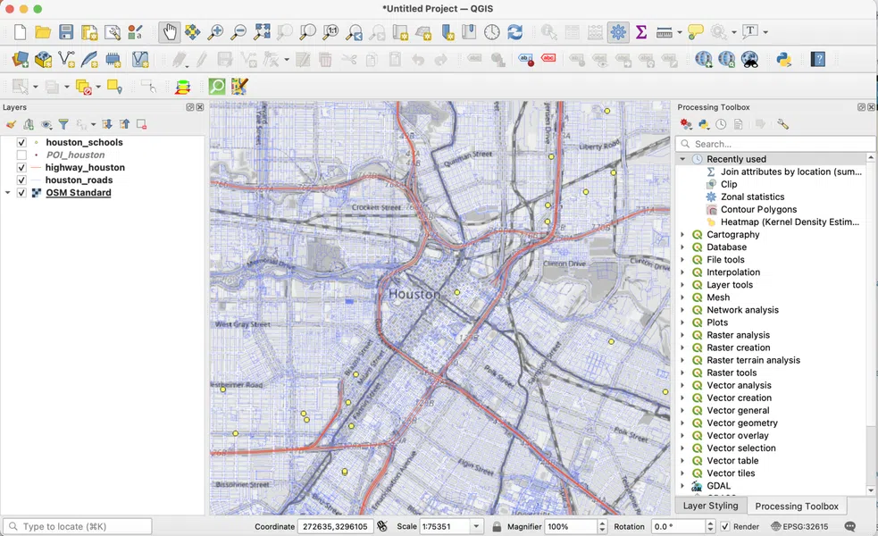
Fig. 1 - Screenshot of QGIS Software Interface. Houston, TX is shown here with layers of roads, major highways, and schools
Georeferenced data: data tied to a spatial coordinate system. All data used in GIS must be georeferenced so they can be visualized.
Spatial analysis: statistical analysis of geographic phenomena to describe, analyze, and predict patterns. Spatial analysis is one of the main reasons scientists use GIS.
GIS History
GIS is the latest step in the history of cartography and humans' need to understand places. Before modern technology, map-making required artistic skill and knowledge of surveying. Before cameras and satellites, maps were made from imagination, observation, and memory.
The introduction of digital data and technology allowed greater accuracy. Remote sensing, aerial photography, and satellite technology supplied early georeferenced imagery and data. This, in turn, fueled a need for GIS. With every new advancement, more people were able to make maps. This is significant because maps are a form of communicating information.
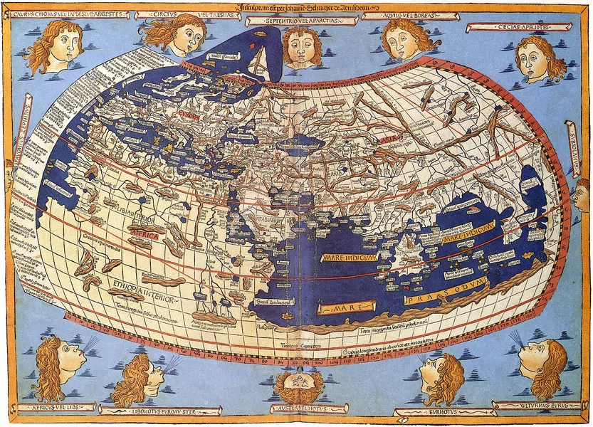
Fig. 2 - Europe, North Africa, and West Asia (1482)
GIS technology began to develop in the 1960s when Roger Tomlinson helped develop the Canada Geographic Information System, one of the first software and hardware programs that digitized images.1 This was further developed by Howard Fisher's Harvard Laboratory for Computer Graphics and Spatial Analysis. Many packages and functions used now were designed by scientists on those teams.
As the potential for analyzing census, resource, and land cover data grew, governments began funding and expanding on GIS through the 1980s. Environmental Systems Research Institute, Inc. (Esri) was founded in 1969 to commercialize GIS technology, with major releases of the application in the 1980s.
GIS and Mapping
There are several important components of GIS that are crucial to building a map and understanding data. The essential components of making maps are data collection, analysis, and visualization. It's not just about observing data, but also interpreting them!
Data Collection
Data collection can take many forms. If you're lucky, there may already be a georeferenced dataset for you to use for your analysis. Otherwise, you will have to capture your data using remote sensing and GPS or digital transfers.
Remote sensing techniques capture direct measurements of the Earth's surface through detections of electromagnetic radiation. This can take the form of sensors attached to a camera, flying above the Earth's surface (aircraft) or in space (satellite). Another way to capture data is through Global Positioning System (GPS) technology, where coordinates are captured on the ground.
If these technologies are not readily available, another process is digitizing hard copies of maps or data. This method is time-consuming, requiring a lot of editing and processing. This is because the maps or data may have been collected before better technology was available or GIS doesn't correctly translate the scans. Regardless how the data were obtained, it's important to have plenty of time to edit and process primary data before analyzing them.
Data Types: Vector and Raster
Maps are made up of layers that include vector or raster data. Vector data are shapefiles, including lines, points, and polygons (areas). Vector layers can include things like roads, rivers, trees, buildings, and land plots.
The main difference is that vector data are objects or landforms with definable boundaries, whereas raster data are a layer of grid data in which each pixel represents a number. That number can be anything from altitude and temperature to soil type.
 Fig. 3 - Layers and vectors in GIS
Spatial Analysis
After we've collected and cleaned up our data, we can now perform different spatial analytical functions. In GIS, these are considered operations or tools. With these tools, you can extract data, overlay features, calculate proximity between features, and perform statistical analysis.3
Depending on the research question, different operations may be needed. For instance, if a land suitability analysis (LSA) needs to be performed, most operations within the raster analysis may need to be used. This can assist in calculating topographic data.
A land suitability analysis (LSA) is a series of calculations within GIS to determine if areas of land are suitable for use. The intended use can be anything from urban planning to agriculture.
Visualization: Final Map
The next step in a GIS analysis is to produce maps. GIS has a range of possibilities to beautify maps by changing colors, symbols, or adding text. This is also where certain data may be highlighted over others. This is part of the communication process in map-making. What do you want people to know about a place?
 Fig. 4 - QGIS Screenshot of Houston, TX median Income in 2010. There are many ways to interpret this map
GIS Application
The application of GIS technology spans many different fields. Generally, these fields fall under scientific research, resource management, or planning. If an understanding of the Earth's surface is needed, GIS can help!
Scientists who need GIS for their research are often in the fields of geography, geology, and engineering. Both scientists and resource managers usually need to conduct studies on natural hazards, climate change, or major changes in land use and land cover.
Planning encompasses urban, transport, and real estate/market planning. For urban and transport planning, it's important to know where a city should focus its resources to build infrastructure and transport links. Analyzing population changes and growth is a great way for a city and its organizations to know where people are moving. Real estate and market planning use the same kind of data and processes to analyze where the highest profitability and costs are located in a city.
GIS Examples
There are some notable examples of applied GIS in decision-making. Especially when it comes to planning professions, the results can be the start of major projects.
Community Planning: Participatory GIS (PGIS)
PGIS involves the public in using GIS to study, understand, plan, and make maps with communities.3 This makes it a more powerful tool for collaborating with residents in neighborhood change.
More governments are investing in online mapping technology and publishing city data than ever before. This has greatly expanded citizen access to city planning maps and the data that support them through open-data platforms. Some cities are also using these tools to understand the needs and concerns of local residents.
In Manchester, UK, the city opened a georeferenced complaint and inquiry about places in the city that needed attention.3 This could be something as simple as an overfilled trash can or bigger issues such as observed crime. The aim was to allow them to create a point on a map with a comment about their observation. City officials can use this information to improve services and places in the city.
Land Use and Land Cover Changes
Scientists, resource managers, and planners are concerned with changes in the Earth's surface. This includes changes in soil, forest cover, and urban areas. For example, remote sensing and GIS technology provide evidence of these transformations as they related to climate change.
Research conducted in Jhelum District, Punjab, Pakistan, found that water availability decreased while housing construction and roads increased.4 This largely affects local farmers, who are dependent on stable temperatures and water. This was captured through remote sensing imagery later processed in GIS. With this evidence, local planners can justify making changes in land-use strategies to ensure farmers' livelihoods are not disrupted.
GIS and Ethics
How relevant is GIS technology for society? Should it be a "neutral" quantitative tool to produce maps and nothing more? Many social scientists argue that GIS poses risks as well as opportunities.
Surveillance
Historically, mapping has been used in military, business, and colonial endeavors, and this did not change with GIS. Critics argue the tool should be restricted and limited, while others believe greater education in the tool can allow for more ethical analysis.
After the terrorist attacks of 9/11/2001, the FBI began building a GIS of mosque locations in the US, believing them to be "risk factors."5 This sparked controversy over whether Muslims, or indeed any group deemed a threat by the government, should be surveyed and tracked in this fashion.
GIS is a powerful tool for governments and businesses. It allows them to visualize where different people live and the places they may frequently visit. Geolocation of residents and their demographic information need better protection to ensure they are not used in a way that harms or targets certain groups.
Political Mapmaking
The increasing use of GIS in redistricting has resulted in controversial gerrymandering cases. While redistricting is meant to accommodate demographic changes within electoral boundaries to ensure representation for residents, gerrymandering is the practice of manipulating those boundaries to gain political power.
Drawing electoral boundaries can be done with both more sophisticated data and faster technology. This means greater precision based on race or political affiliations can be achieved at the scale of individual neighborhoods and streets. While GIS has been used to contribute to the problem, it can also be part of the solution. By using transparent spatial calculations, political leaders and third party supervisors can create ethically-based congressional boundaries.
 Fig. 5 - Congressional District 4 in Illinois, an example of one of the most gerrymandered electoral districts in the US
GIS is part of a methodology for understanding spatial data. What's essential is the purpose behind the analysis. What's the goal of obtaining and visualizing certain points of data? And further, how can it help serve the purposes of society?
GIS - Key takeaways
- A Geographic Information System (GIS) is the integration of data, computer hardware, and software in order to understand, analyze, and illustrate georeferenced data.
- Spatial analysis is the study of geographic events and phenomena in order to describe, analyze, or predict patterns. Spatial analysis is one of the main reasons scientists use GIS
- The essential steps for making maps in GIS are data collection, analysis, and visualization.
- The application of GIS is used in the fields of scientific research, resource management, and planning.
References
- Waters, N. GIS: history. John Wiley & Sons, Ltd. 2017. DOI: 10.1002/9781118786352.wbieg0841.
- Esri. An overview of the Analysis toolbox. ArcGIS for Desktop.
- Kingston, R. Public participation in local policy decision-making: The role of web-based mapping. Cartographic Journal. 2007. 44(2), 138-144. DOI: 10.1179/000870407X213459.
- Majeed, M.; Tariq, A.; Anwar, M.M.; Khan, A.M.; Arshad, F.; Mumtaz, F.; Farhan, M.; Zhang, L.; Zafar, A.; Aziz, M.; et al. Monitoring of Land Use–Land Cover Change and Potential Causal Factors of Climate Change in Jhelum District, Punjab, Pakistan, through GIS and Multi-Temporal Satellite Data. Land. 2021. 10, 1026. DOI: 10.3390/land10101026
- Crampton, J. W. Mapping: A Critical Introduction to Cartography and GIS. Wiley-Blackwell. 2010. ISBN: 978-1-405-12172-9.
Similar topics in Human Geography
Related topics to Introduction to Human Geography


